


City of Kimberley to Remove Peak to Platzl Staircase and Close Portion of Trail
The City of Kimberley will be removing the Peak to Platzl staircase in the coming weeks and permanently closing a portion of the Peak to Platzl pathway between lower Gerry Sorenson Way and Norton Avenue later this fall. This follows an extensive engineering review that identified significant safety concerns along the route.
The staircase has been closed since 2024, during which time the City undertook additional analysis of both the staircase and the trail. Geotechnical, civil, and structural engineers reviewed the site and concluded that there is no feasible solution that would bring the existing route up the pathway or stairs to modern safety standards in a cost-effective manner.
"This is not a decision that Council has made lightly," said Mayor Don McCormick. "We recognize that the Peak to Platzl route has been a valued connection between the Alpine area and downtown for many years. However, public safety must come first."
Engineering assessments identified movement in the staircase foundations, concerns about slope stability at multiple locations, and failure of portions of the retaining wall system that supports the trail. The review determined that repairing the route would require substantial investment with no certainty that a sustainable long-term solution could be achieved.
The area has experienced slope instability in the past. A landslide in 2012 moved an estimated 150 cubic metres of material, equivalent to approximately 15 full dump trucks or more than 1,200 curbside organics carts.
While the existing route will be lost, pedestrian access between the ski hill and downtown will remain available. The alternative route to the Platzl from the ski hill will use Norton Avenue, Swan Avenue, and Wallinger Avenue. The City will improve the existing Swan Avenue pathway by grading and paving the unpaved section along Swan Avenue and will maintain the route year-round. Engineering review found this route to be the most practical and cost-effective option available at this time.
Once improvements to the alternative route have been completed, the impacted section of the trail will be permanently closed. Signage and physical barriers will be installed at both ends, and the route will no longer be maintained, including during the winter months. Planning and design work for the full decommissioning will take place over the coming months, with construction currently scheduled for summer 2027.
The City understands that many residents will be disappointed by the loss of a well-used trail connection.
"This was not the outcome anyone hoped for," said Nik Morissette, Senior Manager of Operations. "After extensive review, engineers concluded there is no feasible solution that would allow the existing route to safely remain in service. Our focus is now on delivering improvements to the alternate route and maintaining a safe connection between the resort area and downtown."
The City will continue to evaluate alternative long-term active-transportation opportunities to improve connections between the ski hill and downtown. The City is currently updating its Active Transportation Network Plan and will consider this connection as part of that review.
Find additional information, maps, frequently asked questions, and project updates below.
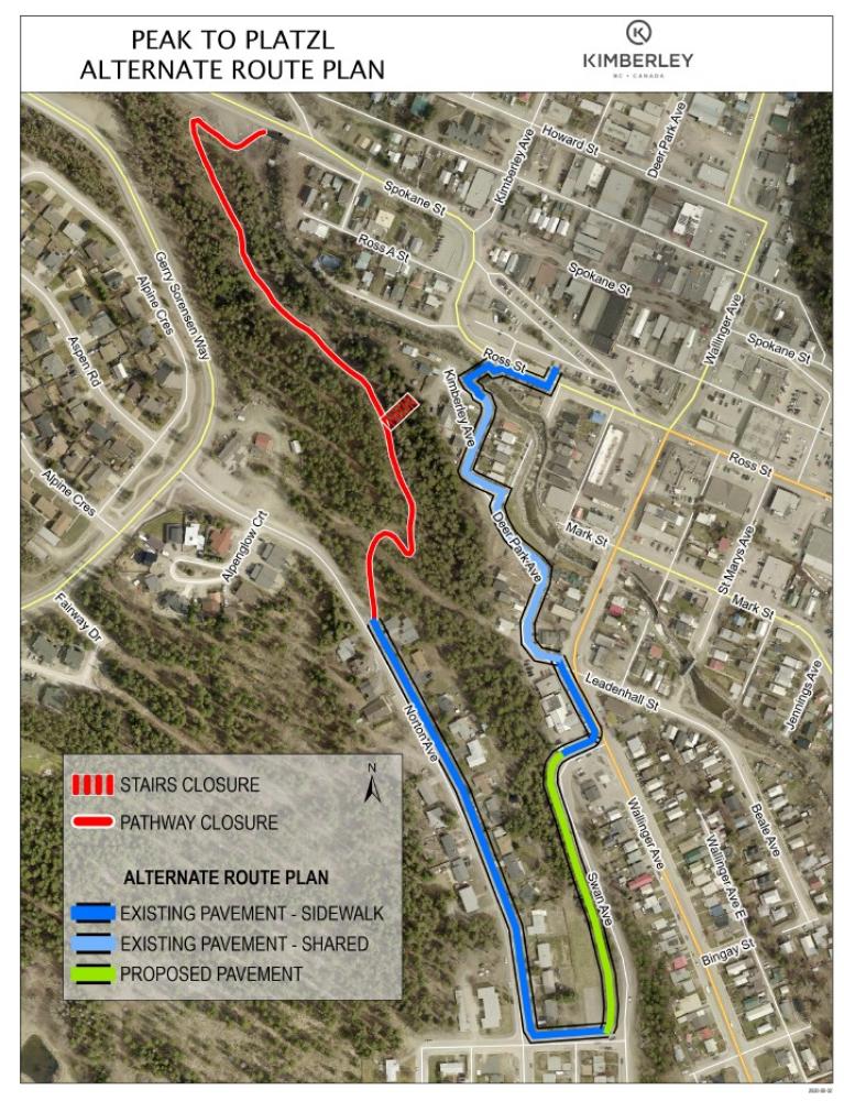
Map of Affected Closure Area
Peak to Platzl Staircase & Trail Closure FAQ
Why is the Peak to Platzl staircase being removed?
The staircase is being removed because it no longer meets modern engineering and public safety standards. Reviews conducted by geotechnical, structural, and civil engineers identified significant concerns regarding the staircase foundations, slope conditions, and the site's long-term stability.
Why can't the staircase simply be repaired?
The City explored the possibility of repairs and rehabilitation. Engineering assessments determined that repairs would be complex, costly, and would still involve significant uncertainty around long-term slope stability. The engineering team concluded there is very little confidence that a cost-effective solution could be achieved with an acceptable long-term design life.
The review also provided an opportunity to consider the broader role of active transportation infrastructure in the community. While the staircase offered a direct connection, stairs are not accessible to everyone. As the City plans for future infrastructure investments, it is striving to ensure transportation and pathway improvements are safe, accessible, and suitable for people of all ages and abilities.
Is this decision because of cost?
Cost is a factor, but safety is the primary reason for this decision.
The City's priority is to ensure that public infrastructure can be safely used by residents and visitors. Engineering reviews found there is no practical solution that would bring the route up to modern safety standards with a reasonable level of certainty and investment.
What safety concerns were identified?
Engineers identified movement in staircase foundations, slope instability concerns, and retaining wall failures along portions of the trail. The staircase area was also found to have an inadequate preliminary factor of safety compared to accepted engineering standards.
Has this area experienced landslides before?
Yes. A landslide occurred at the site in 2012, moving an estimated 150 cubic metres of material. This is roughly equivalent to 15 dump truck loads of soil and rock. The history of slope movement was one of several considerations reviewed during the engineering assessments.
Why is the trail being closed if the staircase is already closed?
The staircase and pathway function as a single connection between the resort area and downtown. Engineering reviews concluded that portions of both the staircase and trail infrastructure face significant safety and stability challenges. The City is taking a long-term approach to ensure public safety and reduce future risk.
When will the staircase be removed?
The staircase is currently closed and is expected to be removed in the coming weeks. Work schedules may vary depending on contractor availability and site conditions.
What will happen to the trail?
The affected section of the trail from lower Gerry Sorenson Way to Norton Ave will be permanently closed later this fall. Barriers will be installed at both ends of the closed section, and the route will no longer be maintained, including during winter months.
What alternative route is available?
Pedestrians can continue to travel between the resort area and downtown using the existing Norton Avenue sidewalk and Swan Avenue pathway connection.
Is the City improving the alternative route?
Yes. The City plans to grade and pave the existing unpaved section of the Swan Avenue pathway and to continue maintaining this route throughout the year, including during winter.
These improvements are intended to provide a safer, more reliable connection for pedestrians and active transportation users.
How much longer is the alternate route?
The alternative route is approximately 300 to 600 metres longer than the existing Peak to Platzl connection, depending on a user's starting point and destination. Engineering evaluations found this route to be the most practical and cost-effective option currently available.
Will people still be able to walk between the resort area and downtown?
Yes. While the Peak to Platzl connection will be removed in this section, pedestrians will continue to have access between the resort area and downtown using the alternative pathways and sidewalks down Norton Avenue to Swan Ave.
Did the City investigate other options?
Yes. Engineering consultants evaluated repair scenarios and multiple alternative route options. The review concluded that improving existing connections offered the most practical solution when compared with the cost and uncertainty associated with repairing the current route.
Why not build a new trail elsewhere immediately?
New pathway options were considered at a high level during the engineering review. Additional routes would require further study, design work, environmental considerations, and funding before they could proceed.
Will the City build another pathway connection in the future?
The City recognizes the value of active transportation connections between the resort area and downtown. While there are no immediate plans for a replacement route, the City will continue exploring future opportunities to improve pedestrian connections in this area.
Why wasn't this addressed sooner?
The City has been monitoring the area and commissioned multiple engineering studies over several years to better understand the condition of the staircase, pathway, retaining walls, and surrounding slopes. Decisions affecting public infrastructure are based on evidence, engineering analysis, safety considerations, and long-term sustainability.
We use this route regularly. Does the City understand people's frustration?
Yes.
The City understands this route is a valued and well-used connection for residents and visitors. We know many people will be disappointed by its closure. This was not an easy decision, but public safety must remain the City's first priority. The City is committed to improving the alternative route and continuing to explore future opportunities for active transportation connections.
What happens if people continue using the closed trail?
Once the trail has been decommissioned, barriers will be installed and the route will no longer be maintained. For safety reasons, residents and visitors will be asked to respect all closures and use designated alternative routes.


 or, more importantly, for play!